The aim of this magazine is to connect the communities of Hindu Kush, Himalaya, Karakorum and Pamir by providing them a common accessible platform for production and dissemination of knowledge.
On Graveyards in Dardistan
This research was done in 1967 by a German anthropologist. It is on the interesting art and designs of the Darada Grave Culture which is a part of the popular Gandhara Grave Culture. The research analyzed the wood work done on the tombs in areas known as Dardistan i.e. Kohistan, Swat, Dir, Diamer, Chitral, Gilgit and parts of Hazara division.
 Uwe Topper 1967
On Graveyards in Dardistan
By Uwe Topper
Introductory Note
The following account of special art and traditions conserved at graveyards of the Indus-Kohistan region had been written to be published in ‘Aspects of Tribal Life in South Asia, vol. II’ editors Rupert R. Moser and Mohan K. Gautam at the University of Berne/Switzerland in 1980.
Few literature after 1974 was included (until Jettmar 1977/8), so it is rather a momentous record without reference to modern anthropological research. It brings information of 1967 when the author himself journeyed in the region of Pakistan-Kohistan and took notes and made sketches of the surprising cemetery art there.
The said vol. 2 of ‘Aspects of Tribal Life …’ never appeared and the article was lost until recently when the typescript copy turned up. The German translation had been published by the Anthropological Museum at Munich:
Topper, Uwe (2000): Grabstelen in Kohistan (Nordpakistan) in: Münchner Beiträge zur Völkerkunde, vol. 6, pp. 313–353 (Munich) here : Kohistan.
Contents of the paper
- Surveying history
- Definition of Kohistan
Dir Kohistan - Swat Kohistan
- Hazara and Indus Kohistan
–History
–People
–Economy and burial habits - Border Regions of Hazara and Indus Kohistan
- Hazara
- The cemeteries
- Designs
- Remarks
Surveying history
When Leitner (1894) describing the mountainous country that stretches from the Hindukush in the West to Kashmir and Tibet in the East first coined the expression “Dardistan” he indicated a broad guide for further research. Since then a number of studies have been devoted to the area, the more important ones being those of Karl Jettmar (esp. 1959, 1965, 1975, and 1977). Through these Dardistan is steadily taking shape emerging as the shadow of a once powerful state which Muslim writers of the first millennium A.D. called Bolor. As it seems to me that Kohistan is the least known part of this area (cf. Jettmar 1975, VI, p. 467 and p. 469 referring to Hazara), the following account is designed to throw some light on the people of Kohistan, their funeral art and customs. Comparison of local variations of Dardic funeral art shows the profound cultural heritage of the whole region that survived successive waves of Hindu, Buddhist, and Muslim missions and conquests.
Definition of Kohistan
During my wanderings in the mountains of Northern Pakistan (1962-67) I found of special interest the regions lying adjacent to the Pathan states because pre-Islamic art forms and customs have been preserved there until today. These regions – usually called Kohistan – are bound to the Parthan states of the North-West Frontier Provinces like semi-autonomous subjugated vassal-states. Their borders are mostly well defined by nature, namely high mountain ridges, steep river gorges, and the like, while the southern borders usually coincide with the northern limit of two harvests per year which implies that the Pathan on their northbound drive occupied the valleys as far as it was rewarding in terms of agriculture leaving the less productive part of the valleys to the indigenous population, the ‘mountain people’ or Kohistanis. Thus Kohistan is the land of poverty, its only wealth being the dense forests which now, too, have fallen prey to exploitation by companies with modern equipment. Another distinction of Kohistan is that their valleys are less easily accessible than other regions and this added to my curiosity. In fact, in some places I happened to be one of the first Europeans intruding and undertaking survey. Jettmar (1977, p. 411, para 1 and fn.3, as well as p. 417, para 4) explains that the lack of safety of the traveller makes it difficult for scholars to visit Kohistan. For the same reason my range of activity – taking notes and sketching of buildings and artifacts like tomb stones as well as questioning people on customs and beliefs – had to be restricted in some places to rudimentary notes. While talking to individuals I gained the impression that Kohistanis are a most hospitable and honest people but have turned into ever ready rebels and even robbers under the enormous economic pressure exercised by the ruling Pathans. An imam in the Panjkorah Valley asked me urgently to tell the outside world how much his people are oppressed by the ruling family of the Nawab of Dir. The limit of what is bearable is considered transgressed some time ago. This short note may suffice to draw an outline of the problem of poverty and repression under which the whole of Dardistan is suffering. It should be noted, however, that since my last stay in the region (autumn 1967) the situation may have improved.
Dir Kohistan
Progressing from west to east the first Kohistani region of Pakistan is the one belonging to the Nawab of Dir. It comprises the Panjkorah valley with its tributaries and the higher part of the river Dir up to the Lowari pass. Its northern borders are snowcovered peaks of more than 5000 m above sea level thus making exchange of goods in that direction almost impossible. The only access to the valleys is from the south, and as this route has been guarded by the Pathans for centuries, the Bashgary[1] speaking Kohistanis were at the mercy of their Pushto speaking overlords. The village Tal[2] at the upper end of the Panjkorah valley shows wooden structures of remarkable beauty. The mosque especially is a marvellous example of Kohistani architecture. Its huge wooden pillars and the beams of its roof are richly ornamented and vividly coloured with designs of leaves and flowers. The capitals bear resemblance to rams’ horns as usual in the Hindukush.
Note 1: Noteworthy is the striking similarity of this mosque in Tal regarding capitals and ornaments with a mosque in Tagundaft (Anti Atlas, Morocco) reproduced in Sijelmassy, Les arts traditionels au Maroc, Paris 1974. –
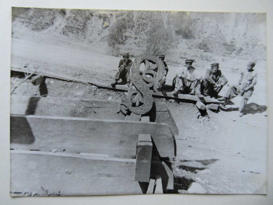
Following the river Panjkorah one reaches a village named Patrak by the Pushto speakers, and Rashkot or Rajkot by the local Bashgary. There I saw a cemetery with wooden trestles. Their four cornerposts are topped with pitchers carved in wood of the type with a spout that is used for ritual ablutions. Beneath the trestle at both ends protrudes a wooden head of a dragon. Spears and flags are displayed at the graves as is usual throughout Islamic Asia. My rapidly drawn sketch gives an idea of the cemetery below the village (fig. 2)


Note 3: As for the wooden pitchers on the posts I could locate only one similar item: In a cemetery in Laghman (Afghanistan) wooden coffins with sloping roofs are placed on the ground, and these have a wooden pitcher with spout on the middle of their ridge (photograph and remark by Peter Snoy, Kabul).
[1] Bashkarik or Gawri speaking people
[2] Thal village
Swat Kohistan
Travelling up-river in Swat State one crosses the frontier of Kohistan at the village Bahrein where a wooden barrier with Police and Customs officer testify to the fact that Kohistan is a separate entity of Swat State. North of this village the population is different from the Pathan in language and custom and has retained independence – slim though it is – which springs to the eye in art expressed in mosques and graves, and in their dances and their social behaviour.
The most important village of that region is Kalam at the confluence of two tributaries (Gabral and Uttror) that form the Swat river.


Many travellers have seen and photographed the mosque of Kalam, and I too did extensive drawings of this impressive construction that has no equal in the whole of the Northern mountain range (see 2 photos above). It was built 40 years ago modelled on the one that stood on the same site before it was destroyed by fire. Beams and columns are so massive that every European is instantly reminded of a Viking temple. The lower part of the building used for the ritual ablutions is completely constructed in wood like everything else in this mosque, and the room for heating in winter reveals remarkable craftsmanship and a long standing tradition of wooden architecture. The “ionian” capitals are distinguished by showing three snails (instead of one) thus enhancing the impression of might.
Right next to the mosque at the edge of the village lies the graveyard which unfortunately had recently been damaged by a landslide. The wooden trestles resemble coffins standing on the ground while the corpses are buried in compliance with Islamic law (Photo-3). Quite often one sees three of such substitute coffins built one into the other. Their corner posts look like Buddhist stupas, and the tips of the boards on the sides are stylized like a bird’s head (fig. 4). The bords on each side as well as the posts standing at both ends are profusely decorated with carved flowers and leaves which seem to denote vines. The standing posts at both ends correspond to tombstones; they are carved like an S and – seen from afar – resemble a horse’s head with neck and breast each one carrying a little crown on its head (fig.5).


Swat-Kohistan, I was told by the imam of the mosque of Kalam, was converted to Islam under the rule of Aurangzeb three centuries ago. Missionaries had preached Islam in these mountain villages before the cruel conquest of Auranzeb and are venerated as saints and martyrs at their respective tombs. Thus the inclination of Kohistanis to worship at graves has found an Islamic expression. Neither the imam nor anybody else in the valley could provide information concerning the religion of the people prior to the conversion to Islam. I can only assume that it was similar to some kind of archaic Shivaism deducing from other regions of Dardistan (cf. Jettmar 1975, III, 17, especially p. 314).
Two villages on the western tributary above Kalam are noteworthy: Utror and Gabral. Their population differs from one another as well as from that of Kalam in dialect and graves. In Utror grave posts are curved like an S topped with crowns of three or five points. They flank wooden coffins in the form of houses of European type although there are none like it in the whole region between Iran and India (fig. 6). It seems here, too, that the more traditional art serving the deceased has preserved memories of house construction that have long been abandoned for the living. There are no villages in Ushu valley, the Eastern tributary of the Kalam river, but it is used as pasture by different people throughout the summer.


Down river from Kalam there are a number of villages which all differ from each other regarding their dialect, handicraft, and customs. The cemetery of Fatehpur shows a great variety of wooden grave posts placed at head and feet of the buried corpse. Here, too, the similarity to Buddhist architecture is striking (figs. 7 and 8). Side by side in Fatehpur one sees anthropomorphic flat wooden stela (see fig. 8 close to the right hand edge) and three-dimensional stupa-like posts.
Several Chinese monks travelled through Swat in the first millennium A.D. and wrote about the outstanding erudition shown at the monasteries of ‘Udyana’ (Swat), among them Fa Hsien (in A.D. 403), Song Yun (A.D. 519), and Hiuen Tsang (A.D. 630). Tucci (1958) has excavated one of the centres of learning at Udegram. It seems that the whole of Dardistan was converted to Buddhism, at least superficially, from the time of Ashoka until the conquest of Turkish commanders. Yet the impact of Buddhism was scanty, maybe due to its tolerance towards other religions.
Hazara and Indus Kohistan
History
The earliest recorded name of this region between the rivers Indus and Jhelum is URASHA surviving today in topographic names such as Orash and Rash Plains. The Mahabharata gibes the spelling URAGA for the same region. Ptolemy notes two names for the land between Indus and Hidaspes (river Jhelum): Arsa Αρσα and Ovarsa Ουαρσα. One of the kings has a similar sounding name, Arsakes (327 B.C.).
The Buddhist conversion of the country by king Ashoka is recorded in rock inscriptions, the best known being that at the foot of Bareri Hill near Mansehra which was a resting place frequented by pilgrims; its date corresponds to the year 272 B.C.
One of the many legends relating to the history of Hindu rulers may be traced back to historical facts: Raja Rasalu who lived at the end of the 2nd century A.D. is said to have subdued a giant named Raksha and imprisoned him in a cave because he had an amorous affair with the queen.
The Chinese traveller Hiuen Tsang who travelled that region between A.D. 629 and 642, calls this land WU-LA-SHI, and its capital Mangali. In those times it was dependent on Kashmir. Another variant of the name, U-LA-CHE, was discovered in Western Turkish documents by Chavannes (1903) as quoted by Jettmar (1977, p. 414). In the 11th century, Urasha was again subordinated to the kings of Kashmir, king Kalasha (1063-1089) gained victory over king Abhaya and his prince and became ruler of Urasha by marriage. Emperor Timur Leng designated his commander Kurlagh Turk governor of the land in 1399, and it is to his army of 1,000 soldiers that the modern name Hazara is traced, hazar in Persian meaning thousand. I am inclined to think, however, that this popular etymology is artificial, as seems to be the case, too, regarding the name of the Hazara tribe in Central Afghanistan, usually derived the same way although it may go back to an Aryan proper name much older than Timur’s invasion.
In the 18th century the Northern part of Hazara was conquered by Swathis under the leadership of the Khan Khel family. These Swathis spell their name with an H to distinguish themselves from the Swatis who stayed in the area now called Swat State. At the same time, the Southern part of Hazara succumbed to the no less proud warriors of the Gakhar tribe. The movement of these tribes towards east was probably caused by the unification of the Pathan nation under Abdul Ghafoor in 1749 (see Badshahi 1963). The Khan Khel came from Thana Bakhta in Swat using mainly an army of Pathan who had settled originally at the river Kurram and in the Shilman region. They had been driven via Tirah and Nashtnagar under Mahmud Ghaznawi into the valley of Swat (cf. Caroe 1962). Under the Khan Khel they set out to conquer new land to the east of the Indus. They drove the Dilazak tribe ahead of them, then followed up closely and slew the indigenous population. Jelal Baba, the leader of the Khan Khel and ancestor of the now ruling Khan was ritually recognized as spiritual and political ruler of the whole land when he victoriously entered the fortress of Nakoth which contains the most sacred tomb of the country (see below). The significance of this tomb is still preserved today: the man who is in possession of this place is considered the rightful ruler of this part of Hazara.
The Khan Khel consider themselves to be ‘Coreish[1]’, in fact they are full blood descendants of the Moghul rulers linked to Timur in direct line which they prove by genealogical tables. Marriage between cousins is a strict rule in order to make an heir’s claim valid. The first born son of such an alliance is automatically destined to be the Khan or ruler of the tribe and the country while the second born becomes Sultan of Bhoy, a stretch of land of strategic importance at the border with Kashmir. Main residences of the Khan are the fortresses of Gari Habibullah and Nilishang. For the subjugation of Kohistan he maintains a small army for which he is paid the sum of one lakh rupees (100.000) by the Pakistan Government each year. As this amount was fixed at the time of British rule it is nowadays utterly insufficient. Therefor the Khan is forced to raid his land from time to time in order to maintain the traditional standard of life expected of him. The people venerate the Khan with a kind of religious awe. I consider the term ‘ritual kingdom’ as coined by Jettmar for the Hunza rulers (1975, p. 239) appropriate.
Among the many cultural events at the court of the Khan recitations of poems and chants in Dari (Persian) and Pashto, less so in Pundjabi or Sindhi, are to be witnessed. Very popular are presentations of dances with sword or for marriages. On festivities horse races are featured, and also typical Hindu dances executed by highly gifted and well munerated professional dancers.
[1][1] Quriash or Kuraish


People
The most important group of inhabitants consists of the Pushto speaking Swathis who settle here since two centuries. They consider themselves to be relatives of the Yussufzai. There are two main branches, the Ghabri (or Utli-Pakhli) who live in Kaghan, Balakot, Gari Habibullah, Konsh, Mansehra, and Shinkiari; and the Mamiali-Mitrawi (or Tarli-Pakhli) who live in Bhairkund, Agror, Tikari, and Daishi. Both branches are farmers and soldiers and owe allegiance to the Khan. Both group names contain old Iranian religious terms referring to the Zoroastrian faith.
The Sayad are considered equal to the first group in social status because they came together with them under Jalal Baba. They settled compactly in the area at the upper river Sirin and in the Kaghan valley. One should not confuse them with the descendants of Muslims who fled from the Turanian cities during the Moghul menace. Those are usually called Sayad comprising Bukhari, Tarimzai, Mashhadi, Bakri, and Gilani. The Khan Khel Sayad do not intermarry with them as they are a different tribe. Their leader bears the title Pirana Pir (Saint of Saints) and is also called Germi Wallah, a position in which he receives an allowance every month from the Khan consisting of one sack of brown sugar and two-and-a-half Rupees. Of course, the value of this allowance has shrunk to mere ritual significance nowadays.
One of the branches of the Sayad are the Shah Khel who are also called Garjr, known as fierce warriors.
An equal status of freedom is conceded to all Khoja (Khwaja): They are merchants and servants.
Likewise the Bamba, descending from royal families in Tanjir and Darel, living under the protection of the Khan, are a free caste.
The great bulk of the indigenous population which was subjugated by the army of the Khan are Hindko speaking Gujr (Gujar). They live in semi-bondage as farmers and servants. These people still preserve pre-Islamic traditions which will be dealt with in part 4. Their priestly tribe, Chechi, has two branches: Bandr and Shurimar; the other tribes are called Kithana, Bumla, Pashwal, Jindr, and Awan. (Nearly all names suggest Aryan origin.)
There are remnants of the Dilazak tribe in Tarbela and Amb at the river Indus and in Chachh (Hazara).
Karral, Dhund, and Sarara live in and near the Sultanate of Bhoy; the latter two tribes intermarry. Before their conversion to Islam they are said to have been Hindus.
The Kohistanis converted to Islam in recent generations live in the higher valleys, especially in Elai, an area considered as not yet pacified. Their heads of family have sworn allegiance to the Khan. The language of the Kohistanis is a form of Hindko called Khodwari.
There are some sections of Powenda, camel nomads of Afghanistan, who pass the winter in Hazara. For this right they have to pay tribute in kind to the Khan. As a branch of the Gandhara nomads they belong to the Paktuike nation (term coined by Caroe 1962 following Herodotus.)
Until partition in 1947 Hazara was a sacred homeland for many Hindu castes, notably Khatri and Arora. Famous poets, artists, and dancers were born there. Some Brahmins as well as dancers and poets still live at the courts of the Khan and other princes where they function as entertainers at festivities. Although living in bondage they are treated with respect by all Muslims.
Economy and burial habits
Only a minority of farmers live around the markets and fortresses, the majority live in hamlets and single farmsteads dotted around the country-side. Farmland as well as buildings are the property of the Khan. The fields are terraced as everywhere, and partly irrigated by water-channels. At low altitudes rice is grown whereas higher up maize and some wheat or barley together with beans, onions, and garlic are the main crop. Cattle is very scarce for lack of pasture-ground except for Kohistan where goats and sheep account for half of the income of the population.
Famous for centuries are the festivities for the deceased, celebrated with great pomp. When a head of family dies, magnificent obsequies are arranged to which relatives from all over the country are invited. The celebration culminates in a ceremony on the third day after the burial, when alms are distributed generously, and all guests are served the best of food and drink in abundance. Originally this took place on the day of the burial three days after death had occurred whereas nowadays according to Muslim law the burial has to be on the day of death.
The tombstones, too, are extremely costly and elaborate, and requiem-type festivities are held at regular intervals after the burial attended by many people. The tombs are cared for by the families every Thursday (therefore called ‘ziyarat roz’ generally a duty of the women who enjoy the excursion with pagan hilarity.
In the more densely populated Southern part of Hazara, Islam has been firmly established since time immemorial. Therefore, the tombs are modelled more on those of their traditional Muslim neighbours to the South: in the towns the usual form of the tomb is that shown in figs. 9.1 and 9.2 where the tombstone is covered with tiles or paint. Poorer people in the country-side erect simple stone slabs on the grave which usually consists of a terrace surrounded by stones as shown in fig. 9.3. Contrary to traditional custom, however, the stone slabs for male corpses are placed long-ways instead of cross-ways to the grave.

Border Regions of Hazara and Indus Kohistan
Following I shall describe traditional burial customs of regions at the Western edge of Hazara District, as around Battal at the upper river Konsh and around Oogi at the river Unar, as well as the valleys of Nilishang, Rajwari, and Elai which are not considered as belonging to Hazara proper.
The cemeteries are dispersed throughout the valleys, most of them being situated on woody hilltops in the vicinity of the hamlets and villages but rarely at their immediate edge. In most cases outstanding spots like rocky elevations, hills overlooking the valley, river bends, or the angle between confluent rivers have been selected for the site. Arable land, however, and the vicinity of wells are prohibited for use as grave-yards. Trees standing on a site of a grave-yard are sacred and must not be cut. This interdiction has saved last remnants of forest in a land where growing aridity is menacing survival. Under those little woods dead are buried and people gather for remembering, devotion and recreation, as well as serving as pasture to the few goats that are kept by the peasants. Usually a footpath passes through the wood thus providing a shady resting place to the traveller. Parts of such a cemetery are built in terraces, fenced in by low stone walls usually grouping families together. Some cemeteries have an open place fringed by walls and trees; its significance is no longer obvious, it seems to have been the dancing ground for festivities combined with the act of burial in former days.
All these appearances give the impression of special social importance to the cemeteries. Some of the graves are covered with planted flowers, mostly irises. On Thursdays, women with their children wander to the grave-yards in small bands carrying food and water. They care for the tombs and make merry the whole afternoon. Therefore this day of the week is called in Pashto: siyarat roz (= tombs day).
The tombs face towards Mekka as usual, although the orientation is less strict where the terrain is uneven or difficult. The tomb stones, however, don’t follow Islamic custom, on the contrary: the stone stands longways when a man is buried and across head and feet when a woman is in the grave.
Two basic types of tombs can be distinguished easily:
Simple earthen heaps with one stone slab at each end to denote head and feet. In this group women’s stones are set long-ways, too, and thus coincide with the usual Islamic practice. The height of stone slab varies between 80 cm and 1.5 m, their width measures around 60 cm, while they are only around 10 cm thick. The material is mostly grey sandstone or slate. They are hewn extremely fine showing patterns of animals, preferably horses, and large birds. As they are not standing upright but protruding obliquely they give the impression of bow and stern of a boat, reminding one of the stem of a Viking ship. The stones are decorated, too, with engraved designs of astral or floral themes. On some stones I saw carvings of tools which obviously denote trade or craft of the deceased. Other designs resemble archaic writing although completely illegible. (see fig. 12-18) from Elai and Nilishang (Hazara).


Terrace-tombs constructed of regular stone slabs with up to three terraces thus looking like flat archaic pyramids. In many cases the stone slabs are ornamented with patterns known from wood carvings: widely employed are interlacing circles, lotus flowers, and grape wines. The four cornerposts imitate wooden structures as well but they are hewn out of sandstone. It looks like in former times wood was used for those figures and posts but due to diminishing forests and scarcity of wood the builders preferred stone.
A combination of the two basic types (4.2.1. and 4.2.2) is noted in recent graves of well-to-do people. The character of wood imitation is carefully preserved. Some of these tombs are built like twins, side by side so that only six cornerposts are necessary. I presume that they accommodate married couples. (fig. 16)
So called Giants tombs are dispersed over the land of Hazara as well as all neighbouring regions. They are usually single graves of about 9 m length hence their popular name Nau Gaza Baba (= nine yards father). They are said to represent the burial sites of Giants (Deo) extinct nowadays but supposed to have lived in recent past and still continue to be alive in the memory of the people who readily tell stories about their deeds. Such a Giant’s grave is surrounded by a circle of rough stones and usually adorned with flags and rags. These dead giants are revered with pagan fervour by the less educated.
The spiritual centre of the Swathi area is the tomb of Dewana Raja Baba at Nakoth lying in the midst of a fortress in Guli Bagh, about 5 km from Baffa. It once was the conquest of this holy place that made the Khan Khel rulers of the land. Every Khan once in his life has to make a pilgrimage to this tomb because it is from here that he receives his sacred authority as ruler of the tribe. Every year in March he has to present a horse and a white cloth to the guardians of the sanctuary. It might be deduced that in former times the fort was sacred to a horse deity which held sway over the installation of the ruler. In this case the expression tomb should not be taken literally; ancient sanctuaries are often given the epithet ‘tomb’ after being incorporated in Islamic devotional practice.
The cult of the Giants is universal to all Northern India. I think it worthwhile to repeat some of the stories people in those marginal areas of Hazara told me:
Story 1: In the old times the DEO lived in the land. They were very tall, up to nine yards high, and they had beautiful women for companions. The eyes of the DEO were set obliquely in their faces (but not vertically as is told in other parts of the mountain range). The original home of the DEO was ‘Kaukasia’ from where they fled when a terrible drought and famine forced them to look for new land. Two tribes, the Jandi Sher and the Sona Sher (sona = gold), conquered the area between Kabul and Hazara owing to their unsurpassable swiftness. They were cannibals, too, and for this reason their spirits are still feared by the population today.
It seems to me quite possible that these popular accounts which are repeated with accuracy in different locations are based on some historical tradition. (In Bagrot and Haramosh similar stories about the ‘Yamalo’ have been recorded by Peter Snoy 1975).
Story 2: Besides the giants there are many stories about fairies (Peri, in Pashto: Hapiro) of extraordinary beauty but some having their feet pointing the wrong way. They congregate around the deep lake of Saf-e-Muluk (sword of the kings) in Northern Kaghan. Moreover, there exist many tales about dwarfs (Bunyan) who have only four fingers on each hand; and about women of the woods (Perli and Rui) who lure young men into the forest and ruin them.
Designs
Among cosmic patterns the sun and the stars are more often represented than the moon. Sun wheels and Swastica signs might stem from the idea of rebirth which is fundamental to all religions of South Asia except for Islam. The recurrent floral and leaf themes show grape vines, ivy leaves, and iris. In contrast, human or animal figures are never depicted realistically but in a highly stylized form maybe due to avoiding confrontation with the puritan Muslim ideology. Intriguing are the holes pierced through the stone slabs; could they be interpreted as gates to the other world similar to those holes in altars of the Kalash which Jettmar explained this way (1975, p. 361)?
The coherence of spiritual values of all tribes from Kafiristan to Baltistan is evident enough to allow inferences from one area into another. Not only the Kohistani wooden grave-posts and the custom of coffins deposited on the ground – even when this is only symbolically in the form of trestles – but also the elaborate festivities for the dead reminded me very much of the Kalash people (see Topper 1977, p. 236 ff). In both tribes – Kalash as well as Kohistanis – the recurrent animal theme for grave-posts is the horse. The Kalash have even a statue of a rider sitting on two horses (in Rumbur, Topper 1977, figs. 18 and 19) while in Swat and Hazara there are stylized yet recognizable horse effigies for grave-posts and stone slabs. Wooden horse heads protrude from all Mahandeo altars and Jashtak columns of the Kalash, while a horse is the tribute the Khan has to give to the holiest place in Hazara each year. It should be noted that those tribes retreated from the plains into inaccessible mountainous terrain and have lived without horses for generations. The force of this tradition seems to be considerable.
Floral and leave themes are less conspicuous to the religious authorities so they could retain more of the ancient symbolism. Ivy and vine are the plants connected to the dead and the other world; they are neither Islamic nor Buddhist nor Hindu symbols but belong to an older religious stratum. The great importance of wine for the Kalash (Topper 1977, pp. 226, 235, 271) and in the Gilgit Agency (Jettmar 1975) has been noted by all travellers. Its outstanding role in the Kalash funeral ceremonies and winter solstice celebration should be underlined in this context.
Incidentally I add that some topographical names in Hazara could be reminiscences of a connection to the Kalash: a village and river East of the Indus in Kohistan are called Kalash Khwar, and several villages in Hazara bear the name Kalas. In Hazara a mountain pass or border point usually is called Kandao which could be the same word as the term Gandao in Kalasha denoting a wooden statue in the form of a person; perhaps the designation Kandao stems from the habit of building up a pile of stones at the pass or border point which vaguely resemble a person.
The great variety of designs in funeral artifacts throughout Kohistan is due to many different influences. It can in part be explained by the remoteness of the hamlets. In fact, the differences in dialect and even physical appearance of the inhabitants from one village to the next is striking. As these people do have detailed memories in form of sagas and poems of their origins and wanderings those should be seriously taken into account when ethnic classification of the Kohistanis is to be undertaken.
On the other hand the similarity of design and customs in funeral art of the whole area of Dardistan give reason to some reflections including the area West of the Durand Line as far as the inhabitants belong to the Dardic group:
There are wooden tomb-posts and trestles in Laghman (Afghanistan) which show a striking resemblance to those of Hazara (see figs. 19-21 made from photographs taken by Peter Snoy). It rather seems that the whole Southern fringe of Kafiristan should be included in this comparison. Badakhshan, at the Northern edge of Nuristan, reveals comparable characteristics as I noticed when visiting Djurm and surroundings in 1967. The people care for their dead with great anxiety and fervor conducting elaborate festivities with banquets for the deceased person and commemorating his death even on great Muslim holidays such as Id-ul-Kurban.
Finally let us look at the Eastern end of Dardistan. The valleys of Tangir and Darel which formerly where administered from Chitral have quite similar funeral art. A wooden post in shape of a kneeling human figure is placed inside a trestle (fig. 22). Jettmar (1960) writes that the design of the wood carvings in both valleys seem to be a direct continuation of Buddhist Gandhara art.


Yet a question concerning the origin of those designs may be put at this stage: From where did the Gandhara artist obtain his rich choice of themes? The sermons of Buddha are not particularly inspiring in this way, whereas Gandhara art has been rightly called a child of Greece. The five-fold Lotus seems to be one of the few symbols left over from a great number of pictographs suppressed by the demythologizing attitude of Buddhism. The Buddhist influence on fine art might rather be described as a selective process reducing the once enormous variety of mythological themes that were at hand to the artist of Dardistan. It is only in his funeral art where he retains his more important imagery because to care for the spirits of the deceased is so deeply rooted in his soul that none of the great religions – not even austere Islam – could eradicate it.
The ancient stratum of religious symbols common to all art from Kafirsitan to Kashmir appears to have been formed or fixed already by the time of the Zoroastrian mission. The custom not to bury the dead but to expose the corpse in a wooden coffin above the ground in forests – today only practiced by the Kalash – probably goes back to the renewal of the Iranian fire-cult under Zoroaster forbidding Fire or Earth to be sullied by corpses.
A great number of topographical and tribal names all over Kohistan sound like Gabr, Ghabr, or Gawr which was the term designating the followers of the fire-cult of Zoroaster (cf. Babur 1926). However, the preponderance of the horse and the near total absence of the cow as sacred animal point to the fact that the ancient stratum must have been different from Zoroastrian and Shivaite religion as well. It rather suggests that Dardistan’s cultural background was fed by a separate force which obstinately survived all religious missions and conquests.
Remarks
Vital conditions like terraced fields, wooden construction of the houses, and dependence on goat husbandry (at the higher altitudes) are predominant features which shaped culture and weltanschauung alike of the tribes regarded here. An example may illustrate this: The six cornerstones of the double tomb in Nilishang (fig. 16) look like human heads topped by cones. The characteristic head-gear of the mountain people is of cone shape, a pointed hood forming part of the felt coat that protects against rain and snow. All male statues of the Kalash wear a turban but the important part is the conical head-gear around which the turban cloth is wound (see Topper 1977, fig. 16). Similarly, the back of the seats at Kalash Mahandeos reveal anthropomorphic shape with a pointed hood (dito, fig. 6,1).
About the author: Born in 1940 in Breslau, Germany, Uwe Topper is an artist and author of a dozen books about art and history in German and Spanish. Some of them have been translated into Russian, Bulgarian and Hungarian (and recently even into Korean). He lives in Berlin/Germany as a self-subsistent artist, writes freelance in several reviews of historical interest and delivers speeches in German, English and Spanish in some small circles interested in history
Editor’s note: The paper was reproduced from http://www.ilya.it with due courtesy.
References
- Some recent literature (after 1974) not included in the article have been added here.
- Areas Handbook of Pakistan 1971. US. Govmt, Washington.
- Babur, Zahir ud-Din Mhd, Memoirs. Transl 1826 from Chagatai into English
- Badshah, Miangul Abdul Wahid 1963: The Story of Swat. Peshawar.
- Barth, Fredrik 1956: Indus and Swat Kohistan. An Ethnographic Survey. Oslo
- Beal, Samuel 1884: Buddhist Records of the Western World, Translated from the Chinese of Hiuen Thsang (A.D. 629). Trübner’s Oriental Series, 2 vol. London.
- Biddulph, John 1880: Tribes of the Hindookoosh. Calcutta (reprint Graz 1971).
- Burton-Page, J. 1986: Muslim Graves of the “Lesser Tradition”: Gilgit, Punial, Swat, Yusufzai. In: Journal of the Royal Asiatic Society, pp. 249-254.
- Caroe, Sir Olaf 1962: The Pathans.
- Chavannes, E. 1903: Documents sur les Tou-Kiue (Turcs) occidentaux. Paris.
- Drews, Frederic 1876: The Jummoo and Kashmir Territories. London. (Repr. 1976: Quellen, Entdeckungsgeschichte und Geographie Asiens, vol.7. Graz)
- Frembgen, Jürgen 1983: Die Nagerkuc im Licht der populären Reiseliteratur – ein Beitrag zur Vorurteilsforschung in Pakistan. In: Snoy (ed.) 1983, S. 147-162.
1998: Religious Folk Art as an Expression of Identity: Muslim Tombstones in the Gangar Mountains of Pakistan. in: Muqarnas. An Annual on the Visual Culture of the Islamic World 15, p. 200-210.
1999: Indus Kohistan. An Historical and Ethnographic Outline. in: Central Asiatic Journal 43, 1, pp. 70-98. Wiesbaden. - Fussman, Gérard 1972: Atlas linguistique des parlers Dardes et Kafirs. Vol. I Cartes – vol. II Commentaire. Paris.
- Gazetteer of Hazara District 1907.
- Grierson, Sir George A. 1929: Torwali. An Account of a Dardic Language of the Swat Kohistan. London.
- Haserodt, Klaus (eds.) 1989: Hochgebirgsräume Nordpakistans im Hindukusch, Karakorum und Westhimalaya. Beiträge zur Natur- und Kulturgeographie. Institut für Geographie, TU Berlin.
- Henninger, Joseph 1983: Genealogien und Geschichtsbewußtsein bei semitischen Völkern. In: Snoy (ed.) l983: 245-261.
- Janata, Alfred 1983: Ethnogenetische Prozesse in West- und Zentral-Afghanistan. In: Snoy (ed.) 1983 :319-330.
- Jentsch, Chr. und Liedtke, Herbert (eds.) 1980 Höhengrenzen im Hochgebirge. Geograph. Inst. der Univ. d. Saarlandes, Saarbrücken.
- Jettmar, Karl 1959: Urgent Tasks of Research among the Dardic Peoples of Eastern Afghanistan and Northern Pakistan. Bulletin of the International Committee on Urgent Anthropological and Ethnological Research, vol. 2.
1960 a: Schnitzwerke aus den Tälern Tangir und Darel. Archiv für Völkerkunde, vol. 14, Wien.
1960 b: Megalithsystem und Jagdritual bei den Dardvölkern. In: Tribus vol. 9: pp. 121-134. Stuttgart.
1961: Die Bergvölker Westpakistans. Erschließung und politische Schicksale. In: Bustan, vol. 3
1965: Fruchtbarkeitsrituale und Verdienstfeste im Umkreis der Kafiren. Mitteilungen der Anthropologischen Gesellschaft, XCV. Wien.
1975: Weinbereitung und Weinrituale im Hindukusch. Festschrift für Helmut Petri, hrsg. von Kurt Tauchmann. Köln u. Wien.
1975RdH: Die Religionen des Hindukusch. Stuttgart.
1977: Bolor. A Contribution to the political and ethnic Geography of North Pakistan. In: Zentralasiatische Studien 11, pp. 411-448. Heidelberg.
1979 Bronzes from North West Afghanistan. In: South Asia Archaeology: p. 295-303. Berlin.
1982 Kafiren, Nuristani, Darden – zur Klärung des Begriffssystems. In: Anthropos 77, pp. 254- 263.
1983 Indus-Kohistan. In: Anthropos 78, pp. 501-518, St. Augustin
1995 The Dards and connected Problems: Giuseppe Tucci’s last contribution. In: Festschrift Giuseppe Tucci. Nel centenario della nascita. I.I.M.E.O. Rom. - Kaiser, Lincoln 1991: Friend by Day, Enemy by Night. Organized Vengeance in a Kohistan Community. Fort Worth.
- Kussmaul, Friedrich 1952-3: Frühe Nomadenkulturen in Innerasien. Bemerkungen zu M. Hermanns : Die Nomaden von Tibet. In: Tribus NF 2 u. 3, pp. 305 f.Leitner, Gottlieb W. 1867-1870: Results of a tour in Dardistan … 4 vol. Lahore.
1870: On the Races and Languages of Dardistan. In: Journal of the Ethnographical Society. London.
1875: Dardistan. In: Geographical Magazine. London.
1894: Dardistan in 1866, 1886 and 1893. Woking. - Military Report and Gazetteer of Indus Kohistan, Black Mountains and Adjacent Territorries 1940. Simla 1941.
- Palwal, Abd erRaziq 1987: Mankiralay. A Political History of Kalam, Swat. Teil I In: Zentralasiatische Studien, 20. Bonn.
1992-3: dito, Teil II; In: Zentralasiatische Studien, 23. Bonn. - Rathjens, Carl und Troll, Carl und Uhlig, Harald 1973: Vergleichende Kulturgeographie der Hochgebirge des südlichen Asien. Wiesbaden
- Raverty, Henry G. 1864: An Account of Upper Kash-Kar and Chitral or Lower Kash-Kar together with the Independant State of Panj-Korah, including Talash. In: Journal of the Asiatic Society of Bengal, vol. 33: p. 125-151.
- Scheibe, A. (Hrg) 1937: DiH Deutsche im Hindukusch. Berlin.
- Schmitt, E. 1971: Ornamente in der Gandharakunst und rezenten Volkskunst im Hindukusch und Karakorum. Wiesbaden.
- Schuster, M. 1960: Zur Diskussion des Megalithproblems. In: Tribus 9, pp. 44-45. Stuttgart; enriched in: Paideuma VII/3. Wiesbaden.
- Snoy , Peter 1965: Nuristan und Mungan. In: Tribus 14, S. 101-148. Stuttgart.
1975: Bagrot. Eine dardische Talschaft im Karakorum. In: K.Jettmar (ed.) Bergvölker im Hindukusch und Karakorum, vol.2. Graz.
1983: Ethnologie und Geschichte. Festschrift für Karl Jettmar. Südasien Institut der Universität Heidelberg, vol. 86. - Spain, James W. 1954: Pakistan’s North West Frontier. in: The Middle East Journal, vol VIII, Washington.
- Stein, Sir Aurel 1928: Innermost Asia. Vol. I. Oxford.The Imperial Gazetteer of India, 1908, vol. XIII. Oxford.
- Topper, Uwe 1977: Beobachtungen zur Kultur der Kalash (Hindukusch). In: Zeitschrift für Ethnologie, vol. 102, pp. 216-296. Braunschweig.
here: Kalasch ZfE
2000: Grabstelen in Kohistan (Nordpakistan) in: Münchner Beiträge zur Völkerkunde, vol. 6, pp. 313–353 (München) here: Kohistan - Troll, Carl 1967: Die klimatische und vegetationsgeographische Gliederung des Himalaya-Systems. In: Khumbu Himal :pp. 353-388. Berlin.
- Uhlig, Harald 1973: Wanderhirten im westlichen Himalaya. In: Rathjens, Troll und Uhlig, pp. 157-167.
- Wilber, Donald N. 1964: Pakistan, its people, its society, its culture. New Haven,USA.

